Coastal Erosion

What is happening?
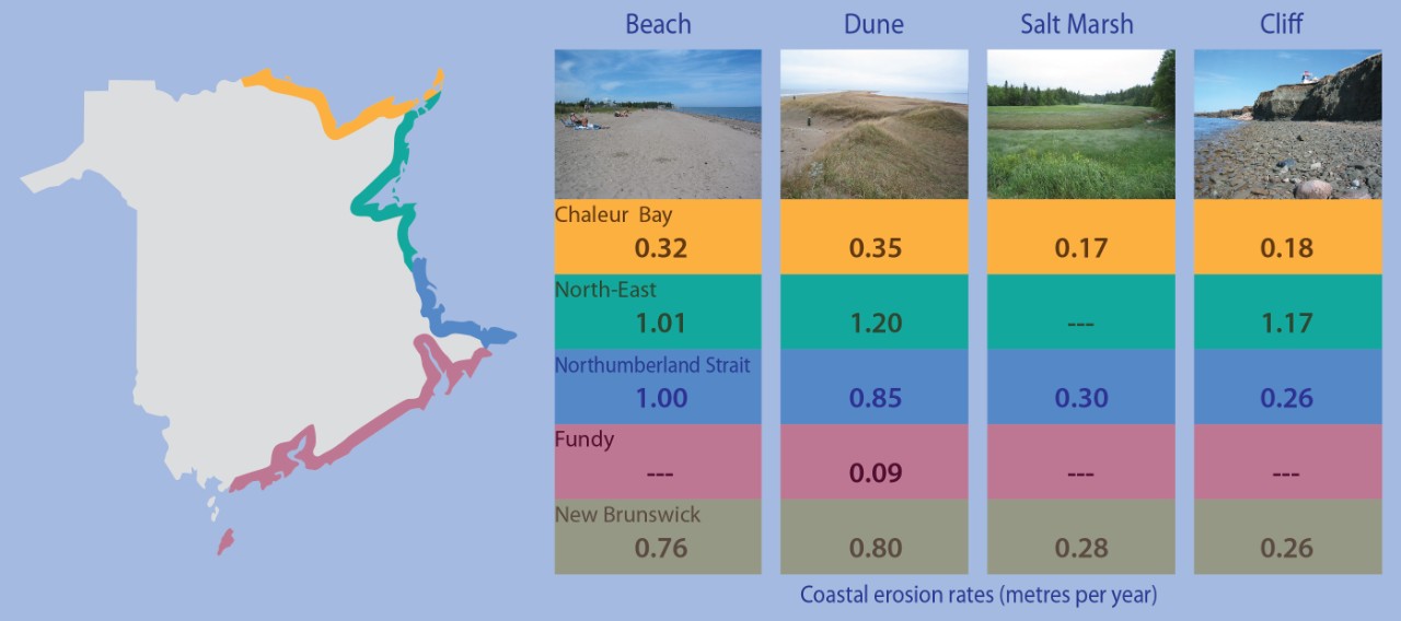
Coasts can move landward, seaward, or be stable. The New Brunswick Department of Natural Resources uses a variety of different land and aerial survey techniques to determine coastal migration rates. The coasts of all landforms (beaches, dunes, cliffs, and salt marshes) in New Brunswick have been eroding. On average, beaches and dunes are moving landward faster than cliffs and salt marshes.
Overall, the Northeast region is experiencing the highest erosion rates, followed by the coastline along the Northumberland Strait, and then Chaleur Bay. The Fundy Coast is experiencing the lowest erosion rates. These regional trends match the predictions made by the Geological Survey of Canada in the 1998 report entitled “Sensitivity of coasts of Canada to sea-level rise”.
Why is it important?
Coastal erosion affects the coastal tourism sector, waterfront property and infrastructure, and coastal ecosystems.
What is predicted to happen?
In New Brunswick, climate change is expected to accelerate coastal erosion rates because of sea-level rise and the increased frequency of extreme storm events. Some coastal ecosystems, such as dunes and salt marshes, provide a natural buffer to help us cope with severe storm events. It is important for New Brunswickers to maintain the natural capacity of beaches, dunes, cliffs, and salt marshes to move landward as sea levels rise. To learn more about coastal zone management in New Brunswick, please refer to the Coastal Areas Protection Policy.
Information source
New Brunswick Department of Natural Resources
