
2012 Crown Forest Management Plan Harvest Blocks | Aerial Survey Results | Pheromone Trap Maps | Spruce Budworm L2 Mapping | Digitized Pest Management Records | Forest, Non-forest and Wetlands | Reforestation | Stand Improvement | Vegetation Management | Forest Roads
Forestry
Spatial location of all harvesting identified in the first 10 years of 2012 Forest Management Plans for Crown timber licenses. Blocks are identified by broad treatment category and by the period (2012-2016 and 2017-2022) they are available for harvest.
Download
Direct Access
- WMS Service (GIS access only): https://gis-erd-der.gnb.ca/server/services/OpenData/Crown_Forest_Management_Plan/MapServer/WMSServer?
- WFS Service (GIS access only): https://gis-erd-der.gnb.ca/server/services/OpenData/Crown_Forest_Management_Plan/MapServer/WFSServer?
- ArcGIS Server: https://gis-erd-der.gnb.ca/server/rest/services
- Folder: OpenData
- Name: Crown_Forest_Management_Plan
- Map Service: https://gis-erd-der.gnb.ca/server/rest/services/OpenData/Crown_Forest_Management_Plan/MapServer
- Feature Service: https://gis-erd-der.gnb.ca/server/rest/services/OpenData/Crown_Forest_Management_Plan/FeatureServer
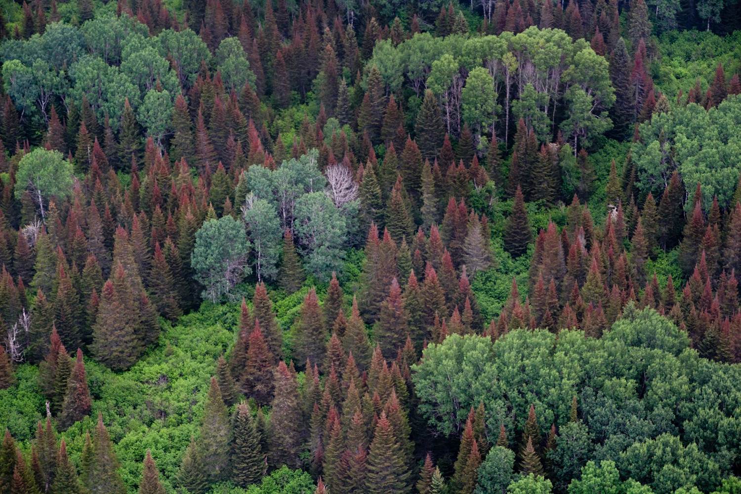
Lines indicate the approximate flight path flown during aerial survey of NB forests for pests, diseases, and abiotic disturbances. Flights are conducted during clear visibility conditions, typically towards the end of June or early July. Observations are timed to optimize visibility of spruce budworm feeding characterized by reddening of current year needles on spruce and fir as they dry out.

Photo courtesy of Natural Resources Canada

Although budworm feeding is often the focus, all types of disturbance are recorded.
Polygons indicate the disturbances observed during the aerial survey. Wherever possible, the cause of the damage is reported from the air and ground surveys are used to confirmed agent if the stand is accessible.
Download
Direct Access
- WMS Service (GIS access only): https://gis-erd-der.gnb.ca/server/services/OpenData/Aerial_Survey_Results/MapServer/WMSServer?
- WFS Service (GIS access only): https://gis-erd-der.gnb.ca/server/services/OpenData/Aerial_Survey_Results/MapServer/WFSServer?
- ArcGIS Server: https://gis-erd-der.gnb.ca/server/rest/services
- Folder: OpenData
- Name: Aerial_Survey_Results
- Map Service: https://gis-erd-der.gnb.ca/server/rest/services/OpenData/Aerial_Survey_Results/MapServer
- Feature Service: https://gis-erd-der.gnb.ca/server/rest/services/OpenData/Aerial_Survey_Results/FeatureServer
The Forest Health Section currently monitors for two insects using pheromone traps. Pheromones are the chemical signal insects created by the insect for communication. Pheromones are used for numerous types of communication. In some species they are used to call other insects together (e.g. aggregation), in some they are used to repel others (e.g. anti-aggregation), in most insects these chemical signals are very specific and unique. Scientists have been able to identify and reproduce these chemicals in many species, allowing us to monitor species presence/absences and relative abundance in pest management. For both
a) spruce budworm

Photo courtesy of Natural Resources Canada
and
b) hemlock looper,

the sex pheromone is emitted by the female to attract male moths. The Province places traps containing pheromone lures for both throughout the province.

At the end of the season, the number of moths found in the traps give an indication of population trends for that season. These result support additional monitoring efforts such as the SBW fall population forecast. The pheromone traps are useful tools, but they only provide a partial picture on populations because in the case of both spruce budworm and hemlock looper the pheromone attract the male moths only.
- Each marker on the spruce budworm map represents three traps hung in a 40m spacing array, the value posted is the average of the three traps counted.
Hemlock Looper:
Download
Direct Access
- WMS Service (GIS access only): https://gis-erd-der.gnb.ca/server/services/OpenData/Pheromone_Trap_Maps/MapServer/WMSServer?
- WFS Service (GIS access only): https://gis-erd-der.gnb.ca/server/services/OpenData/Pheromone_Trap_Maps/MapServer/WFSServer?
- ArcGIS Server: https://gis-erd-der.gnb.ca/server/rest/services
- Folder: OpenData
- Name: Pheromone_Trap_Maps
- Map Service: https://gis-erd-der.gnb.ca/server/rest/services/OpenData/Pheromone_Trap_Maps/MapServer
- Feature Service: https://gis-erd-der.gnb.ca/server/rest/services/OpenData/Pheromone_Trap_Maps/FeatureServer
Spruce Budworm:
Download
Direct Access
- WMS Service (GIS access only): https://gis-erd-der.gnb.ca/server/services/OpenData/Pheromone_Trap_Maps/MapServer/WMSServer?
- WFS Service (GIS access only): https://gis-erd-der.gnb.ca/server/services/OpenData/Pheromone_Trap_Maps/MapServer/WFSServer?
- ArcGIS Server: https://gis-erd-der.gnb.ca/server/rest/services
- Folder: OpenData
- Name: Pheromone_Trap_Maps
- Map Service: https://gis-erd-der.gnb.ca/server/rest/services/OpenData/Pheromone_Trap_Maps/MapServer
- Feature Service: https://gis-erd-der.gnb.ca/server/rest/services/OpenData/Pheromone_Trap_Maps/FeatureServer
Spruce budworm is the most destructive, native defoliating insect in eastern Canada. When budworm populations reach outbreak levels, significant ecological and economic damage occurs (see www.healthyforestpartnership.ca for more details). In New Brunswick, budworm populations are tracked through numerous surveys annually. In the fall, the budworm hatch from eggs, crawl to a secure location on the branches of trees and spin a small web to protect them from the winter elements. They will stay in this location, dormant, throughout the winter and into the spring of the following year before emerging to feed on the new needles of spruce and fir branches.

This life stage is known as the second larval stage or “L2” for short, and it is an ideal time to sample populations. The survey is significant task, and members of the Forest Health section are aided by regional GNB staff and forestry industry cooperators in collecting the nearly 2000 sample locations across the province. The branches from this survey are taken to Forest Health lab in Fredericton where they go through a “wash” that separates the tiny budworm from the branches. Their numbers are then counted and used to develop maps of spruce budworm populations.

These populations are used by the Healthy Forest Partnership research program to develop early intervention strategies to avoid to impacts of outbreak populations.
Download
Direct Access
- WMS Service (GIS access only): https://gis-erd-der.gnb.ca/server/services/OpenData/Spruce_Budworm_L2_Mapping/MapServer/WMSServer?
- WFS Service (GIS access only): https://gis-erd-der.gnb.ca/server/services/OpenData/Spruce_Budworm_L2_Mapping/MapServer/WFSServer?
- ArcGIS Server: https://gis-erd-der.gnb.ca/server/rest/services
- Folder: OpenData
- Name: Spruce_Budworm_L2_Mapping
- Map Service: https://gis-erd-der.gnb.ca/server/rest/services/OpenData/Spruce_Budworm_L2_Mapping/MapServer
- Feature Service: https://gis-erd-der.gnb.ca/server/rest/services/OpenData/Spruce_Budworm_L2_Mapping/FeatureServer
The Department of Natural Resources and Energy Development (DNRED) has archived images of wall maps that represent pest management treatment plans from 1952-1993. The level of detail of the maps varies greatly over the 40 years of records. Typically, these maps are at a scale of 1:500,000 where 1 centimeter represents 5 kilometers on the ground. The archived treatment plans outline the broad application blocks. Considerable effort was made to digitize these maps in a more accessible format by DNRED and NRCan-CFS. Images were ground referenced and individual treatment polygons were outlined for all years from 1952-1993 so that they could be used in modern geographic information systems. The process of creating a digital map from a hand drawn map is not perfect and slight differences are expected. For additional information on the data you can visit Digitized Pest Management Records (arcgis.com)
Metadata and supporting documents for these layers can be downloaded from https://nbdnr.maps.arcgis.com/sharing/rest/content/items/1fa10a4c69ec46bea3160e44ffb96b78/data
Download
Direct Access
- WMS Service (GIS access only):https://gis-erd-der.gnb.ca/server/services/OpenData/Historical_Pest_Treatment_Records/MapServer/WMSServer?
- WFS Service (GIS access only):https://gis-erd-der.gnb.ca/server/services/OpenData/Historical_Pest_Treatment_Records/MapServer/WFSServer?
- ArcGIS Server: https://gis-erd-der.gnb.ca/server/rest/services
- Folder: OpenData
- Name: Historical_Pest_Treatment_Records
- Map Service: https://gis-erd-der.gnb.ca/server/rest/services/OpenData/Historical_Pest_Treatment_Records/MapServer
- Feature Service: https://gis-erd-der.gnb.ca/server/rest/services/OpenData/Historical_Pest_Treatment_Records/FeatureServer
The Renewable Resource Inventory Section of the Forest Planning and Stewardship Branch is responsible for generating an updated Forest (FO), Wetland (WL), and Non-forest (NF) layer annually. Photo interpretation of digital aerial photography (DAP) and the Canopy Height Model (CHM) derived from LiDAR are used in combination to produce these layers. The Forest layer provided here is for New Brunswick Crown Land only. Wetlands (WL) and Non-forest (NF) are displayed for the entire Province. It should be noted that these layers should not be confused with regulatory layers provided by other Departments, specifically, Wetland layer provided by ELG.
The Digital Aerial Photography acquisition schedule can be seen in Figure 1:

The LiDAR acquisition Schedule can be seen in Figure 2:

Metadata for these layers can be downloaded from https://nbdnr.maps.arcgis.com/sharing/rest/content/items/b75088805aae416ab1dba016fc7086fb/data
Wetland:
Download
Direct Access
- WMS Service (GIS access only): https://gis-erd-der.gnb.ca/server/services/OpenData/Wetland/MapServer/WMSServer?
- WFS Service (GIS access only): https://gis-erd-der.gnb.ca/server/services/OpenData/Wetland/MapServer/WFSServer?
- ArcGIS Server: https://gis-erd-der.gnb.ca/server/rest/services
- Folder: OpenData
- Name: Wetland
- Map Service: https://gis-erd-der.gnb.ca/server/rest/services/OpenData/Wetland/MapServer
- Feature Service: https://gis-erd-der.gnb.ca/server/rest/services/OpenData/Wetland/FeatureServer
Non-forest:
Download
Direct Access
- WMS Service (GIS access only): https://gis-erd-der.gnb.ca/server/services/OpenData/Non_Forest/MapServer/WMSServer?
- WFS Service (GIS access only): https://gis-erd-der.gnb.ca/server/services/OpenData/Non_Forest/MapServer/WFSServer?
- ArcGIS Server: https://gis-erd-der.gnb.ca/server/rest/services
- Folder: OpenData
- Name: Non_Forest
- Map Service: https://gis-erd-der.gnb.ca/server/rest/services/OpenData/Non_Forest/MapServer
- Feature Service: https://gis-erd-der.gnb.ca/server/rest/services/OpenData/Non_Forest/FeatureServer
Forest:
Figure 3:

Download
Dataset featuring the spatial location of reforestation (plantation) treatments on private woodlots and provincial Crown lands. The dataset is a record of silvicultural treatments going back to 2005 which is used to inform the history of forest management activities on private woodlots and provincial Crown lands.
Download
Direct Access
- WMS Service (GIS access only): https://gis-erd-der.gnb.ca/server/services/OpenData/Reforestation/MapServer/WMSServer?
- WFS Service (GIS access only): https://gis-erd-der.gnb.ca/server/services/OpenData/Reforestation/MapServer/WFSServer?
- ArcGIS Server: https://gis-erd-der.gnb.ca/server/rest/services
- Folder: OpenData
- Name: Reforestation
- Map Service: https://gis-erd-der.gnb.ca/server/rest/services/OpenData/Reforestation/MapServer
- Feature Service: https://gis-erd-der.gnb.ca/server/rest/services/OpenData/Reforestation/FeatureServer
Dataset featuring the spatial location of stand improvement (precommercial thinning, plantation cleaning) treatments on private woodlots and provincial Crown lands. The dataset is a record of silvicultural treatments going back to 2005 which is used to inform the history of forest management activities on private woodlots and provincial Crown lands.
Download
Direct Access
- WMS Service (GIS access only): https://gis-erd-der.gnb.ca/server/services/OpenData/Stand_Improvement/MapServer/WMSServer?
- WFS Service (GIS access only): https://gis-erd-der.gnb.ca/server/services/OpenData/Stand_Improvement/MapServer/WFSServer?
- ArcGIS Server: https://gis-erd-der.gnb.ca/server/rest/services
- Folder: OpenData
- Name: Stand_Improvement
- Map Service: https://gis-erd-der.gnb.ca/server/rest/services/OpenData/Stand_Improvement/MapServer
- Feature Service: https://gis-erd-der.gnb.ca/server/rest/services/OpenData/Stand_Improvement/FeatureServer
Dataset featuring the spatial location of vegetation management (silvicultural herbicides) treatments on provincial Crown lands. The dataset is a historical record of silvicultural herbicide treatments which is used to inform the history of forest management activities on provincial Crown lands.
Download
Direct Access
- WMS Service (GIS access only): https://gis-erd-der.gnb.ca/server/services/OpenData/Vegetation_Management/MapServer/WMSServer?
- WFS Service (GIS access only): https://gis-erd-der.gnb.ca/server/services/OpenData/Vegetation_Management/MapServer/WFSServer?
- ArcGIS Server: https://gis-erd-der.gnb.ca/server/rest/services
- Folder: OpenData
- Name: Vegetation_Management
- Map Service: https://gis-erd-der.gnb.ca/server/rest/services/OpenData/Vegetation_Management/MapServer
- Feature Service: https://gis-erd-der.gnb.ca/server/rest/services/OpenData/Vegetation_Management/FeatureServer
The data represents roads not maintained by the Department of Transportation and Infrastructure whose primary purpose is to access the forest resources on crown or private land within the province.
Download
Direct Access
- WMS Service (GIS access only): https://gis-erd-der.gnb.ca/server/services/OpenData/ForestRoads/MapServer/WMSServer?
- WFS Service (GIS access only): https://gis-erd-der.gnb.ca/server/services/OpenData/ForestRoads/MapServer/WFSServer?
- ArcGIS Server: https://gis-erd-der.gnb.ca/server/rest/services
- Folder: OpenData
- Name: ForestRoads
- Map Service: https://gis-erd-der.gnb.ca/server/rest/services/OpenData/ForestRoads/MapServer
- Feature Service: https://gis-erd-der.gnb.ca/server/rest/services/OpenData/ForestRoads/FeatureServer