The Chignecto Isthmus is located along the border between New Brunswick and Nova Scotia. It is the only road and rail connection between the two provinces. Located near the Northumberland Strait and Bay of Fundy, the isthmus is threatened by rising sea levels and more frequent severe weather events.
The Chignecto Isthmus is situated slightly above sea level. A network of dykes and aboiteaux originally installed in the late 1600s currently protects communities, infrastructure, private lands and natural resources from rising sea levels.
The Trans-Canada Highway and CN Rail line carry approximately $35 billion per year in goods and services through the isthmus. In addition, the region is home to windmills and major power transmission lines.
The New Brunswick Department of Transportation and Infrastructure and the Nova Scotia Department of Public Works have worked together with Transport Canada to complete the Chignecto Isthmus Climate Change Adaptation Engineering and Feasibility Study.
The comprehensive engineering and feasibility study identifies three recommendations for the protection of the trade corridor located within the Chignecto Isthmus.
These recommendations provide a variety of options to raise the dykes to the necessary level of protection for the isthmus.
The Government of New Brunswick and Government of Nova Scotia are working together with our federal partners to identify and move forward with the right solution.
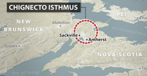
The Chignecto Isthmus is located along the border between New Brunswick and Nova Scotia and is the only road and rail connection between the two provinces. Located near the Northumberland Strait and Bay of Fundy, the Chignecto Isthmus is threatened by rising sea levels and more frequent severe weather events.
The isthmus is situated slightly above sea level. A network of dykes and aboiteaux originally installed in the late 1600s currently protects communities, infrastructure, private lands and natural resources from rising seas levels and storms.
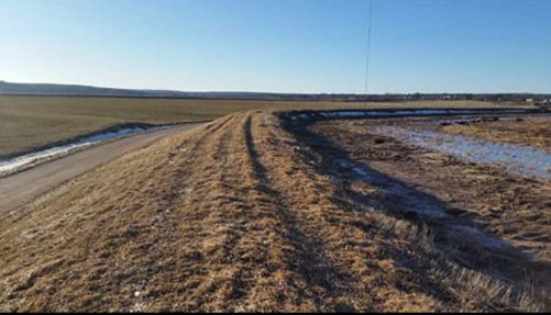
The Trans-Canada Highway and CN Rail line carry approximately $35 billion per year in goods and services through the Chignecto Isthmus. In addition, the region is home to windmills and major power transmission lines.
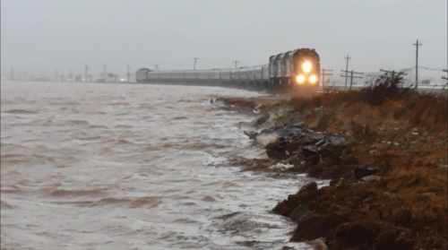
The Chignecto Isthmus is currently protected by a network of earthen dykes originally constructed in the late 1600s to assist with the establishment of farms in the area.
Rising sea levels and more frequent severe weather events threaten the isthmus. For example, there is a risk of flooding in the area that could cause significant damage.
A network of dykes to protect the land from the tides was installed in the late 1600s in the area around the Chignecto Isthmus.
Now a network of 35 kms of dykes and aboiteaux, the system must be enhanced.
The Chignecto Isthmus Climate Change Adaptation Engineering and Feasibility Study identified three viable and potential solutions for the protection of the trade corridor located within the Isthmus.
The estimated timeline for implementation of each option would be 10 years to allow for all necessary environmental assessments, permitting, geotechnical and engineering design work, archaeological work and construction.
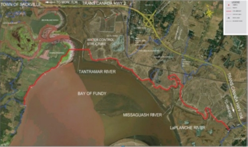
Raise the existing dykes to approximately 10.6 metres. Where required, existing dykes will be connected by new alignments. Water level control structures would be required downstream of existing bridges.
Figure ES.3 General Arrangement Drawing for Option A
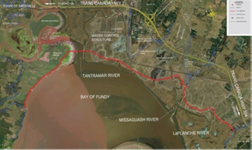
Build a new dyke system to be constructed to approximately 10.6 metres. Water level control structures would be required downstream of existing bridges.
Figure ES.4 General Arrangement Drawing for Option B
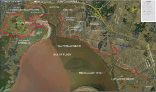
Raise existing dykes along the existing alignment to approximately 10.6 metres. In addition, approximately 800 metres of Steel Sheet Pile walls would be installed at selection locations. Where required, existing dykes will be connected by new alignments. Water level control structures would be required downstream of existing bridges.
Figure ES.5 General Arrangement Drawing for Option C
New Brunswick and Nova Scotia are working to advance the planning activities for a new dykeland system capital infrastructure solution for the Chignecto Isthmus to compliment and improve the existing dykeland system infrastructure for the protection of inland assets.
The two provinces are working closely to improve best
practices and standards for constructing and maintaining
dykeland systems by engaging key groups/individuals,
researchers, and engineering experts.
Over recent years, there have been several studies on the impacts of climate change and rising sea levels in the Atlantic Region. In addition to these studies, an engineering analysis assessing the feasibility of potential options to provide protection to the existing transportation network and infrastructure has been completed. Given the growing climate change risk to the Chignecto Isthmus, the Provinces have decided to collectively undertake pre-construction activities to ensure readiness of one or a combination of the options identified in the Feasibility Study to protect the Chignecto Isthmus.
Technical and non-technical considerations will be incorporated into the design solution for the project. Considerations include, but are not limited to, engineering, soil conditions, hydrotechnical, constructability, archaeological, environmental, Indigenous consultation, and engagement with key groups/individuals.
Developing preliminary work approach - prioritizing the main areas of focus.
Engagement early in the project is key to success - it provides transparency and opportunity to gain insight and knowledge necessary for the design.
Design options are determined through various technical analyses, engagement with key groups/individuals and Indigenous consultation along core stages of the project.
Engagement plans are under development based on early input. Check back for updates to specific and upcoming project activities.
The final design will be based on a systems approach to provide an effective solution with the dyke upgrades, creating one dykeland system within the New Brunswick-Nova Scotia based project corridor. In addition to conventional infrastructure solutions, such as raising dyke heights or the application of rock to provide shoreline protection, it is expected that design methodology will consider the use of natural infrastructure solutions where possible, such as living shorelines, saltmarsh restoration, and saltmarsh generation.
Definitions
Aboiteau(x) - Aboiteau is singular, aboiteaux is plural. A water control structure consisting of a tide gate at the end of a culvert that regulates water flow between a tidewater area and a drained upland area. Can be a box or pipe culvert individual, stacked or parallel.
Agricultural Marshland – Area of marshland protected behind the dyke that is predominantly, but not exclusively, used for agricultural purposes.
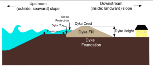
Dyke – An embankment constructed of earth or other suitable materials whose purpose is coastal flood risk reduction or water conveyance. Commonly referred to as a dyke, dike, levee, or embankment.
Dykelands – Predominantly agricultural lands developed from rich salt marshes found mainly in the upper Bay of Fundy of Nova Scotia and New Brunswick. Occurring in areas of high tidal range, dykelands owe their existence to dykes constructed to keep out the sea. They primarily protect agricultural marshland, as well as residential and commercial property, roads, railroads, and utility lines.
Foreshore Marsh – Area of vegetated marsh that exists within the intertidal zone. Foreshore marshes are valuable sources of coastal protection due to their capacity to attenuate waves and their ability to accrete with rising sea levels.
Isthmus – An isthmus is a narrow strip of land that connects two larger land masses and separates two bodies of water.
Marsh – An area of low-lying land which is flooded in wet seasons or at high tide, and typically remains water-logged at all times.
Marshland (wetland) – a region, area, or district characterized by marshes, swamps, bogs, or the like and often found at the edges of lakes and streams, and coastal areas where they form a transition between the aquatic and terrestrial ecosystems.
Salt Marsh – Salt marshes are coastal wetlands that are flooded and drained by salt water brought in by tides.
HOVER POINTER OVER IMAGE FOR MORE INFORMATION
Dyke
Reinforcement
Dyke
Realignment
Tidal Wetland
Restoration
Aboiteau/Upgrades
Rehabilitation
Aboiteau
Construction
Drainage
Improvement
Management Plan
It is anticipated that the project will involve rehabilitation, potentially the relocation of and/or decommissioning of existing water control structures (e.g. aboiteaux), and new construction to upgrade the dykeland system. It will include:
Total cost estimated at approximately
$650M
Planning and Preliminary Project Activities Phase 2023-25
Initiate regulatory and permitting activities
2024
Design and
Engineering Phase
2024-27
Construction
Phase
2027- 2034
Indigenous engagement and engagement with key groups and individuals to be carried out for the duration of the CIRP. Provinces will consider their respective Indigenous consultation requirements before applying for regulatory authorizations and permits.