Robert Murray
Pumpkin Hill
Commodity: Gold, Copper, Silver, Lead, Zinc, Cobalt
Claim block number (units): 10110 (50)
NTS Location: 21 H/05
Contact Information: 506-566-1962
[email protected]

Commodity: Gold, Copper, Silver, Lead, Zinc, Cobalt
Claim block number (units): 10110 (50)
NTS Location: 21 H/05
Contact Information: 506-566-1962
[email protected]

Copper mineralization is associated with a vertical, northeast-trending chlorite-pyrite vein on the upper east face of a quarry. The vein cuts intermediate intrusive rock of the Cambrian quartz diorite, up to 1 m wide, exposed in the quarry face for over 10 m.
There are other unmineralized chloritic veins/zones in the quarry that appear to be fault-related, with evidence of shearing along the veins. The original mineralization was discovered in a large local quarry has been extensively excavated to a depth of 50 m from the top of the mountain. The upper portion of the quarry is primarily limestone, with an exposed granite and diorite Precambrian base. The chlorite wedge/vein that was discovered on the upper east face wall of the quarry extends from 3 m below the top of the mountain to the floor of the upper-level and is exposed for approximately 10 m. The base of the wedge is approximately 5 m across and strikes in a southwesterly direction through the quarry. There is long, well-defined crustal scale fault that strikes northeast to southwest from the Cedar Camp area, near Poley Mountain, southwestward to French Village, near Quispamsis, crossing the Hammond River at this location. The excavation of the quarry has exposed an overlying layer that is composed of a younger sedimentary sequence and the underlying basement igneous rocks. These basement rocks are believed to be significantly older plutons and part of a sequence of three or four plutons that have formed along the crustal scale fault. There is evidence of contact metamorphism from some combination of friction and heat, created mostly by movements along the fault, which is a conduit for the deposition of metallic sulphide minerals. These sulphides took advantage of the numerous fissures and cracks created in the igneous rock by the movements of the fault and seeped into the cracks while in a fluid state, then cooled and hardened in these cracks. Some of these anomalous pockets are very rich in metals, primary iron pyrite, copper, zinc, and also cobalt. It is believed that the stockworks present in the quarry at Pumpkin Hill is fairly large and mostly unexposed, for the width of the deposit becomes significantly larger as the quarry has been excavated deeper.
Previous Work: Limited work has been done on these claims. Two previous prospectors held the claims and conducted limited geochemical work. In 1995, Kevin Sharp (NB Mineral Report of Work 474650) discovered dense concentrations of copper minerals in the center of a large chlorite vein identified in two opposite walls of the pit. Sample #5 assayed gave 3,800 ppm Cu, 1,100 ppm Mn, and 26 ppb Au (Report No. 30897) confirming the presence of the copper. He noted that as the excavation of the quarry by D.O.T. in 1995 continued deeper, to a depth of 150 ft, the chlorite vein begins to show evidence of arsenopyrite along with the copper.
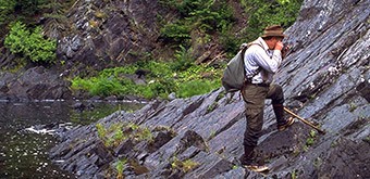
2021 Season: The 2021 prospecting season began with the discovery of outcrop containing mineralization identical to the mineralized outcrop in the quarry on strike of the fault 1,950 m. Assays returned 33 ppb Au, 32 ppm Ag, 8,870 ppm Cu, 2.7% Zn, 1.7% Pb, and 984 ppm Co (Table 1), highlighting the potential size of the mineralization zone along this fault (Photos 1, 2 and 3). In addition to this new discovery, extensive prospecting of the quarry and surrounding area has demonstrated that the cobalt bloom is associated with mineralizing fluids, stockwork veining, and mineralized faulting (Photo 2).
2021 Updated Results
The assay results from the gravel pit has outlined an extensive zone of copper mineralization with assays running 0.38% Cu to 0.73% Cu (see Map 3). Additionally, four additional zones of copper mineralization up to 0.89% Cu have been identified resulting in additional claims being filed to cover an extensive copper mineralized magnetic anomaly lying northwest of a crustal scale fault (see Map 4).