Government of New Brunswick

Stop 1 (photo pending)

Large sections of Albert Formation are exposed on either side of the west- and east-bound lanes of the divided highway west of Sussex. These outcrops illustrate the two essential elements of a petroleum system: source rocks and reservoir rocks. The boundary between the Frederick Brook Member (source) and the overlying Hiram Brook Member (reservoir) of the Albert Formation is particularly well exposed in the sections on both sides of the west-bound lane.

The Frederick Brook beds are brown, kerogenous to highly kerogenous, dolomitic, parallel-laminated to micro-laminated shales and laminated mudstones. The more organic beds will ignite under a flame. These beds typically show slump folds at several scales. The overlying Hiram Brook Member comprises interbedded grey sandstone and shales. The sandstone beds show parallel laminations and excellent examples of wave ripples. The sandstone beds also show low angle small scale planar cross beds and very small scale trough cross beds.

The Frederick Brook Member is typical of the deep organic-rich lacustrine facies of the Albert Formation and is more than likely the main source rock of the oil and gas resources in the Albert Formation, for example the gas at the McCully Field. The Hiram Brook sandstone, with its wave ripples is considered representative of the lacustrine sands that host the McCully gas.

       

Stop 2 (photo pending)

In exposures along Highway 1 south of Hampton, the Kennebecasis Formation (Horton Group) consists of interbedded red and locally grey arkosic sandstone and pebbly sandstone, polymictic conglomerate and mudstone that dip gently towards the west and northwest. The formation lies unconformably on Neoproterozoic basement at the eastern end of the Carboniferous rock exposures. In outcrops on the north side of the west bound lane of Highway 1, about 2.9 km south of the Hampton interchange and just past power transmission lines that cross the highway, steeply dipping and east-west-trending fractures and sheared brecciated zones exhibit minor normal offsets and contain barite +/-calcite. Barite +/- calcite also occurs as veinlets and pods in the matrix of selected conglomerate and coarse-grained pebbly sandstone horizons peripheral to structural zones at some localities, which suggests that these represent emanations from the veins into surrounding, more permeable beds.

Obvious mineralization consisting of malachite and minor disseminated chalcopyrite is present in one, 20 cm-wide brecciated zone.  Minor amounts of sphalerite, galena and chalcopyrite was also observed in polished thin sections of barite-rich rocks from the permeable sandstone horizons several tens of meters north of the larger brecciated zone. Further to the west along the north side of the highway immediately above the unconformity with crystalline basement, malachite stained reduction spheres were also observed. Although of minor economic importance at this locality, this style of structurally-related barite-vein mineralization serves to demonstrate the potential for more significant base-metal sulphide mineralization found at a few localities elsewhere in Carboniferous rocks (e.g. at Memramcook East, south-eastern New Brunswick).


Stop 3 (photo pending)

The outcrops at Bloomfield show the gradational nature of the Albert/Bloomfield boundary. Contact relationships, along with palynomorph assemblages date both formations, and nearly conclusively demonstrate that the Bloomfield Formation is concordant with the Albert Formation and therefore represents the upper part of the Horton Group sedimentary cycle.

Stop 3a – The Bloomfield Formation is exposed in an abandoned quarry on the south side of the Bloomfield Road. The section in the quarry is seen to coarsen upwards from the north (lower beds) to south (higher beds). The northern basal beds are grey to olive and chocolate brown shales and mudstones with thin interbeds of rippled sandstone. Up section there is a 15 cm bed of light grey lumpy limestone calcrete. Further up section the chocolate mudrocks are interstratified with more abundant and thicker beds of sandstone that are commonly graded and range from very coarse-grained or pebbly at their base to fine-grained and rippled at the top. Cross beds are present in some of the coarse sands. Load casts and mud injection structures in the sand beds and sandstone dykes in the mudstones can also be seen.

Stop 3b – Outcrops of the Hiram Brook Member of the Albert Formation are exposed on Highway 1 north of the Bloomfield exit ramp on the south side of the east-bound lane. The north end of the section, which is about 150 metres long, is dominated by beds of dark grey shale with thick channelled pebbly and granular sandstone intervals. Up section towards the south there are minor reddish brown and olive mudstone intervals, locally with caliche nodules (paleosols). The red intervals and paleosols indicate oxidation and exposure surfaces implying the cessation of lacustrine deposition in the Albert Formation and the initiation of terrestrial (fluvial) deposition, which becomes the norm in the overlying Bloomfield Formation.


Stop 4

Carbon_Photo-57

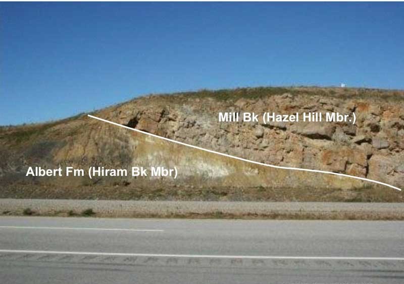
The unconformity between the Albert Formation of the Horton Group and the Mill Brook Formation of the Sussex Group is exposed along Highway 1 at the crown of the hill at Lower Cove. At this location dark grey shale of the Hiram Brook Member of the Albert Formation is abruptly overlain by the locally distributed Hazel Hill Member of the Mill Brook Formation. The Hazel Hill conglomerate is an anomalous thin basal interval of the Mill Brook Formation that is only observed in the area between Lower Cove and Sussex Corner. It consists of light grey to buff competent pebble and cobble conglomerate and quartzose sandstone, with rare beds of grey-green mudstone. The unconformity is demonstrated by the regional angular discordance between the underlying Albert beds and overlying Mill Brook beds [not readily apparent at this outcrop] and the fact that the upper Horton Group section (Bloomfield Formation seen at Stop 3a) is missing at the contact.


Stop 5

Carbon_Photo-58

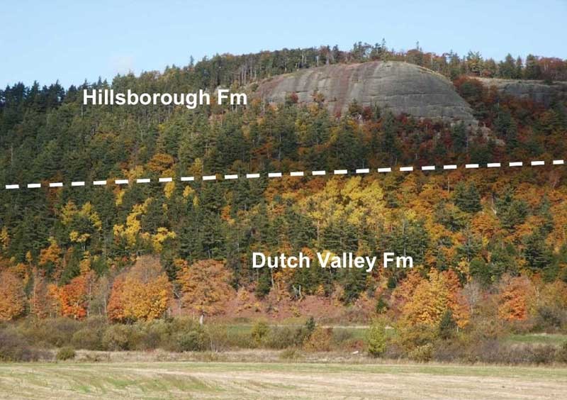
Rocks of the Sussex Group are disconformably to unconformably overlain by the Hillsborough Formation of the Windsor Group (stratigraphic column). This boundary, although not exposed here, can be inferred by the occurrence of red mudstones of the Dutch Valley Formation (Sussex Group) at the toe of the slope on the north side of Trout Creek at Dutch Valley, and the presence of massive cliff-forming conglomerate of the Hillsborough Formation (basal Windsor Group red beds) that forms the rock face at the top of the ridge. The relationship can be observed by looking across the field from the road on the south side of Trout Creek.


Stop 6 (photo pending)

The contact between the Hillsborough and Macumber formations marks the transition from alluvial to marine conditions in the Windsor Group. On the ridge near the water tower at Sussex Corner the contact is not exposed, however, it is concordant elsewhere.

Polymictic conglomerates, lithic grits and sandstones of the Hillsborough Formation form prominent exposures that mostly define the steeper southwest face of the bluff. Clast composition, clast size, distribution and deposit shape suggest that the Hillsborough Formation was deposited in an alluvial fan complex sourced from the south and thinning towards the north. The detritus in the Hillsborough Formation is with near certainty derived from the Precambrian Caledonia terrane to the south. The Macumber Formation limestone is exposed near the well house and in the grassy field with bushes, to the northwest of the well house. There, the limestone is typical of the Macumber in that it comprises parallel laminated pelloidal packstone and wackstone layers. One outcrop of limestone in the field at the top of the ridge shows quite spectacular folds, the origin of which is debatable (slumps or tectonic?). You may find that the limestone will emit a bituminous odour when freshly broken.


Stop 7

Carbon_Photo-59

At this stop we visit the Goshen Copper prospect located between Goshen and Upper Goshen. Mineralization occurs within very poorly sorted, angular clast, polymictic conglomerate of the Sussex Group. Copper minerals identified are malachite, chalcocite, azurite, chalcopyrite and covellite, which occur in the conglomerate matrix, as pebble coatings and as fracture and cavity fillings. The copper mineralization extends over an area 120 m x 25 m, but has little continuity at depth. Although it is not entirely clear what type of deposit it represents or exactly when the mineralizing event took place, a supergene model, involving remobilization of primary sulphides by low temperature oxygenated meteoric water near surface has been proposed.

However, the location of the Goshen prospect along the Gordon Falls Fault, a significant regional basin-bounding fault, highlights the importance of these structures and the potential role they play with respect to the migration of mineralizing fluids.

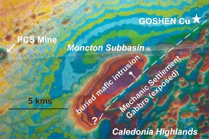
In the Goshen area, this fault defines the northern margin of crystalline basement rocks of the Caledonia Highlands, which nearby are composed of the Mechanic Settlement Gabbro, a copper-PGE-bearing layered mafic-ultramafic intrusion. A recent high resolution aeromagnetic survey conducted by the GSC over this area (Kiss et al., 2004) has also revealed the presence of a buried mafic intrusion in the hanging wall of this fault. The close proximity of the Goshen prospect to these potential sources of copper suggests it may be related to copper-bearing solutions migrating along this fault.


Stop 8

Carbon_Photo-60

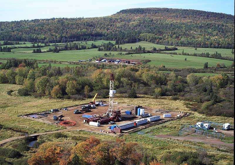
At this stop there are two producing wells, PCS/Corridor McCully A-67 and P-66, which supply about 2 million cubic feet of natural gas per day to the nearby PCS potash mill. There are also two gas wells at this site, Corridor/PCS McCully D-57 and O-66, which have been fracced and will produce gas in early 2007 when the lateral pipeline to the Maritimes and Northeast Pipeline is completed. The McCully Field is estimated to contain in excess of one trillion cubic feet of gas in the Hiram Brook Member of the Albert Formation. The reservoir comprises lacustrine and fluvial sandstone intervals several metres thick (informally labelled by Corridor as sands A, B, C, D, and E) lying between thicker intervals of grey shale. The reservoir sands, at a depth of greater than 2 km, are trapped in an anticline beneath the unconformity at the base of the Sussex Group