The Electoral Boundaries & Representation Commission is mandated to redraw the boundaries of the existing 49 electoral
districts ensuring the number of electors in each riding is as close as reasonably possible to the electoral quotient.
The links below are the PDF images of the maps, as contained in the commission’s amended final report.
This page also contains an interactive digital viewer of the new electoral map, which allows individuals to easily zoom in to each of the electoral districts using their mouse.
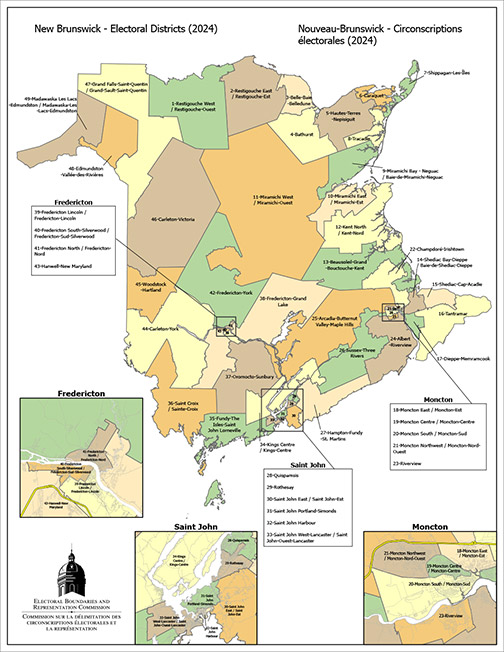
Electoral District Interactive Map - Note: To view a digital interactive version of the electoral map click on the above link. This map viewer provides online access to the provincial electoral boundaries described in the Amended Final Report. The viewer allows you to zoom in and out on the electoral districts using your mouse or the + and – symbols on the screen. |
ESRI Shape Files
Provincial Electoral District Maps
- Electoral districts (8 x 11)
- Electoral district (30 x 30)
1-Restigouche West
2-Restigouche East
3-Belle-Baie-Belledune
4-Bathurst
5-Hautes-Terres-Nepisiguit
6-Caraquet
7-Shippagan-Les-Îles
8-Tracadie
9-Miramichi Bay - Neguac
10-Miramichi East
11-Miramichi West
12-Kent North
13-Beausoleil-Grand-Bouctouche-Kent
14-Shediac Bay-Dieppe
15-Shediac-Cap-Acadie
16-Tantramar
17-Dieppe-Memramcook
18-Moncton East
19-Moncton Centre
20-Moncton South
21-Moncton Northwest
22-Champdoré-Irishtown
23-Riverview
24-Albert-Riverview
25-Arcadia-Butternut Valley-Maple Hills
26-Sussex-Three Rivers
27-Hampton-Fundy-St Martins
28-Quispamsis
29-Rothesay
30-Saint John East
31-Saint John Portland-Simonds
32-Saint John Harbour
33-Saint John West-Lancaster
34-Kings Centre
35-Fundy-The Isles-Saint John Lorneville
36-Saint Croix
37-Oromocto-Sunbury
38-Fredericton-Grand Lake
39-Fredericton Lincoln
40-Fredericton South-Silverwood
41-Fredericton North
42-Fredericton-York
43-Hanwell-New Maryland
44-Carleton-York
45-Woodstock-Hartland
46-Carleton-Victoria
47-Grand Falls-Saint-Quentin
48-Edmundston-Vallée-des-Rivières
49-Madawaska Les Lacs-Edmundston